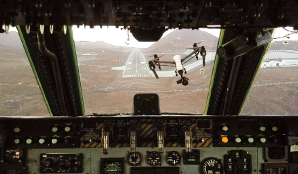
View from the cockpit of a Lockheed Martin C-5 Galaxy.
Wrong. It is a little more complicated than that.
If you enjoy flying drones, even as a hobby – you’ve unwittingly thrown yourself into the world of aviation. As an aviator, there are certain responsibilities that inherently come with the territory. The moment you lift off and send your drone into the heavens, you become responsible for any damage or injury it may cause to property or people. This includes other aircraft, and is no small responsibility. It is important to understand how your actions can affect the lives of others both in the air and on the ground.
In this post I’ll run through some things drone pilots can do to minimize the risk of having a midair collision with full scale aircraft. I will also provide you with links to some helpful documents and online tools you can use to be a better, more knowledgeable drone pilot. I have flown both drones and normal aircraft which range in size/complexity – from a Cessna 152 to a C-5 Galaxy. Therefore this writing comes from a shared perspective.
How to reduce the risk of midair collisions with full scale aircraft:
- Understand Minimum Safe Altitudes as they apply to pilots of full scale aircraft
- Always fly with a spotter
- Learn how to read aeronautical charts
- Know what type of airspace lies above you
- Visit your local FBO and take a flying lesson
- Familiarize yourself flight operations unique to your local area
1. Understand Minimum Safe Altitudes as they apply to pilots of full scale aircraft
Why it’s important: There is a myth in the drone community that as long as you keep your drone below 400 feet above ground level (AGL), you will be clear of all full sized aircraft. This is simply not true. Knowing about federal regulations pertaining to Minimum Safe Altitudes for aircraft will help you understand where you may find full sized aircraft operating below 400 feet AGL.
Here are the FAA’s Legal definitions of Minimum Safe Altitude:
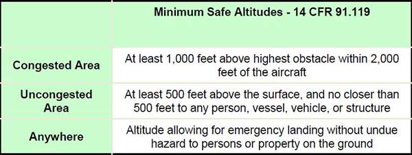
I will elaborate on these definitions as they can be confusing. The first thing you’ll notice are the terms: Congested Area, Uncongested Area, and Anywhere. The FAA has defined a Congested Area in order 8700.1 – the General Aviation Inspector’s Handbook, as follows:
Congested and Uncongested Areas: The congested nature of an area is defined by what exists on the surface, not the size of the area. While the presence of the nonparticipating public is the most important determination of congested, the area may also be congested with structures or objects. An area considered congested for airplane operations could be equally congested for helicopters. If an airplane flying over a congested area at less than 1,000 feet above ground level (AGL) is in violation of 14 CFR § 91.119(b), the area may also be a congested area for a helicopter conducting external-load operations. However, the most important word in this concept is over. Helicopters can operate over relatively small uncongested areas because of their maneuvering abilities.
That gets pretty specific in some regards, but leaves the term “Congested Area” as it applies to Federal Aviation Regulations, completely open to interpretation by the FAA on a case to case basis. I generally (and subjectively) interpret it this way: If an aircraft is flying over a bunch of people and/or buildings – it’s a congested area. If it is flying over trees with a home or occasional person, vessel, vehicle, or structure scattered here and there about the landscape, the area is uncongested. Operating in Congested and Uncongested Areas are not likely to pose problems for drone operators in most cases. WHY? Well because in those areas, the closest a full scale aircraft should be to any person, vessel, vehicle, or structure is 500 feet. This is where the drone community gets the over-generalized and inaccurate 400 foot rule from.
Generally in a Congested or Uncongested area, if you operate your drone at or below 400 feet AGL, you should be clear of any full scale aircraft — assuming the operator of the full scale aircraft is following the law and completely on top of his altitude control. Keep in mind, aircraft pilots sometimes inadvertently dip below minimum altitudes. They are human, and humans make mistakes. Operating a drone at 400 feet AGL in an area where a full scale aircraft’s minimum altitude is 500 feet AGL gives us a fudge factor of only 100 feet. While that’s a lot for a drone, it is relatively easy to lose/gain 100′ in a regular aircraft.
Also, keep in mind the way the FAA mentioned helicopters and how the concept of “over” can be interpreted differently based on the maneuverability of a helicopter. For instance: if a helicopter is being operated in a rural area where homes are 3 miles apart – it may be perfectly legal and safe for the helicopter pilot to land in clearings found in areas of open land or even to fly below 500 feet AGL at times. Because of its maneuverability, a helicopter can accomplish flight maneuvers safely over a relatively small patch of area while maintaining a wide lateral distance from any person, vessel, vehicle, or structure. As a matter of fact – I was recently at a boating get-together on the Hudson river. I really wanted to fly my drone and get some footage over the crowd – but the fellas chipped in and hired their very own chopper pilot. Was it safe for me to fly my drone? NO, not at all. Here’s what that looks like over what would otherwise have been an awesome spot for a drone flight:
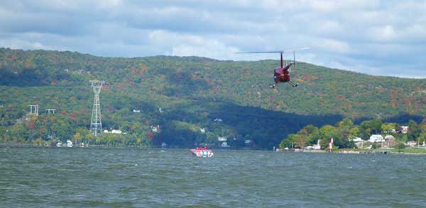
Boating on the Hudson River with helicopter flying low.
Aircraft often operate at low altitudes in places like Alaska, where a bush pilot may need to come in for a low pass to inspect a potential landing strip in the wilderness. There may also be a need to fly low to avoid weather or high mountain winds. Once again, pilot and his aircraft is always at risk, but as long as there is no undue hazard to people or property on the ground – it is perfectly legal. Most drone operators don’t understand this rule, and it has led to the myth that maintaining at or below 400 feet AGL with your drone will keep you clear of full scale aircraft at all times. I can assure you that maintaining at or below 400 feet AGL will NOT keep you clear of full scale aircraft at all times, and hopefully now you have a better understanding of why. Another important fact to note is that Military Aircraft do not always follow FAA rules and regulations with regard to MSAs. That reminds me of a real life story I have about recently seeing a full scale aircraft operating at an altitude below 400 feet AGL. Here goes.
Army Blackhawk at the Beach: Some time ago, I was flying my little drone leisurely out at the beach in Eastern Long Island. My wife was serving as the spotter and the sky was overcast with mild winds and weather. The sand was generally deserted and I was making passes between the beach and the ocean at altitudes ranging from 20 feet AGL to 200 feet AGL, at distances of no more than 800 feet away laterally. Our location was not in the immediate vicinity of any airports/airspace and there no real presence of humans to avoid on the sand. After the flight, pleased with my video footage, I landed the drone without incident and we were just hanging out enjoying the empty beach. Suddenly we began hearing some loud noise from the east.
An Army National Guard Blackhawk whizzed by the shoreline in a very speedy, loud, and cool looking fashion. They were flying the at about 200 feet AGL, maybe 500 feet away from the beach laterally. They were moving at around 50-60 knots in my estimate. This Blackhawk just flew through the exact airspace I was operating my drone in. I knew it was possible, but seeing it happen 10 minutes after I landed shocked me and woke me up to the reality that I could have just caused a midair collision. Was I being safe while flying? Yes. I wasn’t doing anything reckless, and my spotter was looking for birds and aircraft. Was the Blackhawk following the law? Yes, maybe he was a little closer in than 500 feet though. Would I have been able to avoid his aircraft had I been flying at the same time he passed? Maybe. Probably. I don’t know.
It would depend on 2 factors: 1) Whether or not myself or my spotter identified the aircraft in a timely manner. 2) Whether or not I would then take the appropriate action to avoid the collision. The fact that even I, both a drone and aircraft pilot with a decent amount of knowledge and experience, cannot answer that question with a resounding “YES, of course I could have avoided that Blackhawk with 100% certainty” — is a problem. The FAA needs to create some concrete laws, operating procedures, and minimum equipment requirements for drone pilot ASAP. Transponders and ADS-B might be dandy ideas.
Would I have been the one to blame had my drone impacted the Blackhawk? I’d say YES. WHY? In my opinion, full scale aircraft take precedence over drones because of the fact that they have one or more people on board and that the lives of those people should not be put at risk in any way because someone wants to fly a small scale unmanned aircraft or drone around. No flying operation conducted by a drone pilot is more important than the lives and safety of people that are in the air aboard full scale aircraft. Your ass is simply not on the line when you fly a drone, which is one reason people have an easy time being wreckless.
2. Always Fly with a Spotter
Why it’s important: While flying your drone you are capable of paying close attention to it possibly nearby obstacles that are stationary. We’ve all been surprised by the occasional bird fly by. Moving objects like birds and aircraft are more difficult to detect because our field of vision and point of focus is limited. We are fixated on the drone and its flight path, which makes it impossible to scan 360 degrees. Therefore it is essential to have someone present who can focus on visually clearing the area of sky to the left, right, behind, and above your drone.
Not all spotters are created equal! Give your spotter a safety briefing – do not expect them to know what to do unless you’ve worked with them before. Explain to the spotter that he or she should not be staring directly at your drone the entire flight. A spotter’s job is to be aware of the location and directional path of your drone while constantly scanning the sky for dangers that might cause a safety issue for your flight. This entails scanning 360 degrees of skyline and being close enough to communicate verbally with the drone pilot. A good spotter will help maintain safety on every flight.
3. Learn how to Read Aeronautical Charts
Why it’s important: Aeronautical charts depict the location of airports and different types of airspace. It is important for a drone operator to always know where the nearest airport is and what type of airspace is overhead. Therefore, knowing how to read an aeronautical chart is essential.
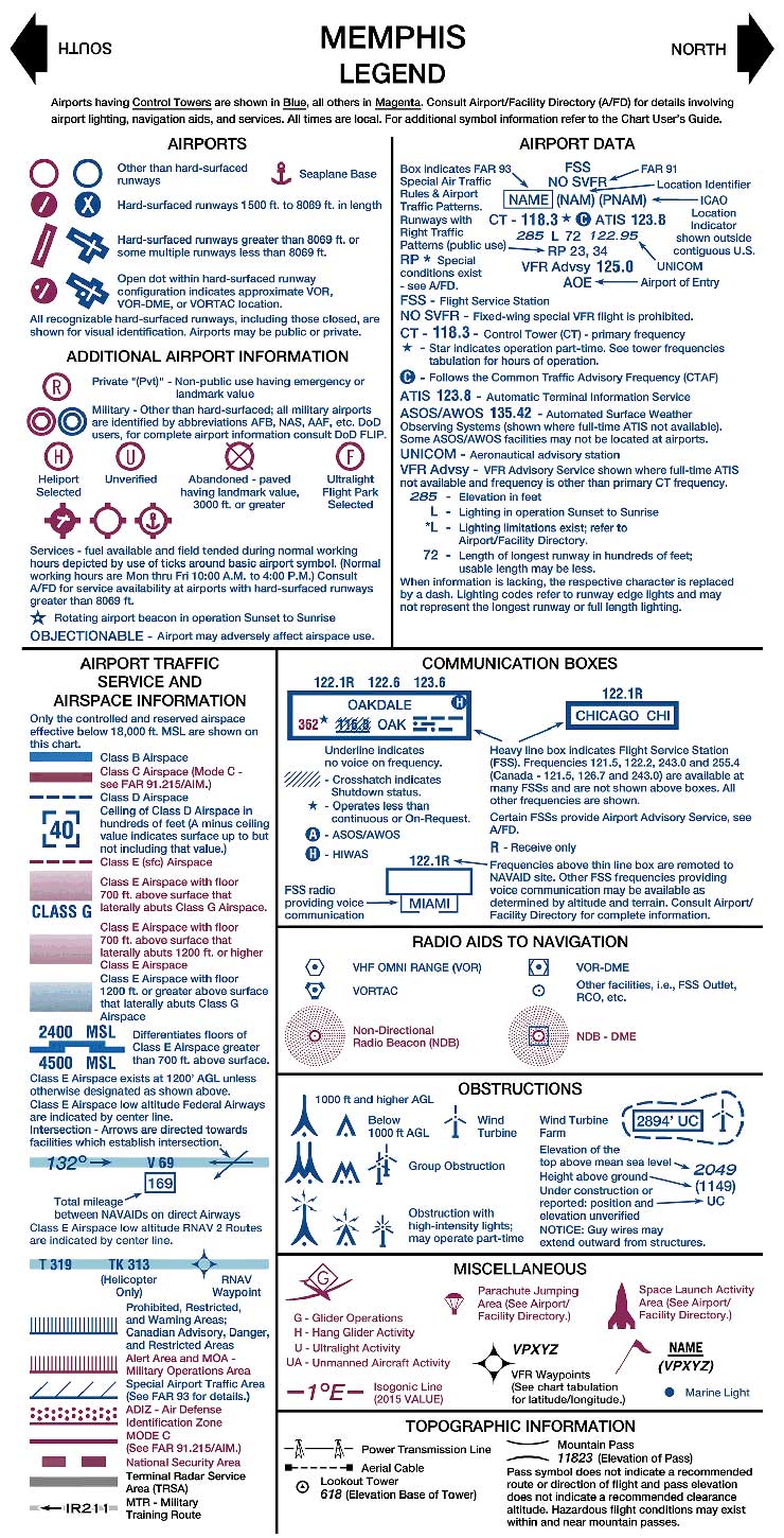 I will not go through every symbol on each type of chart, however, I will inform you that every aeronautical chart has a legend on it (click on image to the right!). The legend describes the meaning of all the symbols and airspace markings on the chart. I will also direct you to a publication which runs through each item on a chart in depth. There are 2 types of charts drone operators should be familiar with:
Sectional Aeronautical Charts: The aeronautical information on Sectional Charts includes visual and radio aids to navigation, airports, controlled airspace, restricted areas, obstructions, and related data. These charts are updated every six months. The legend above is from a Sectional Chart.
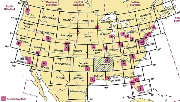
Terminal Area Charts: These charts provide a large-scale portrayal of selected metropolitan areas. The information found on these charts portrays much more detail than is found on the Sectional Charts because of the larger scale. These charts are intended for use by pilots operating from airfields within or near Class B and Class C airspace. Coverage of Terminal Area Charts are indicated by shaded boxes on the Sectional Chart index. Most of the symbols and graphics used carry over from the Sectional Chart. These charts are updated every six months.
Below is an image depicting the areas of the USA covered by each sectional chart (areas outlined in solid black line) and terminal area chart (magenta boxes). Drone operators should review both the sectional and terminal area charts for any location in which they plan to fly.
4. Know what Type of Airspace Lies Above You
Why it’s important: Knowing the type of airspace in the area of your planned flight will help you determine if your flight can be conducted safely. Based on the type of air traffic that is likely to be using that airspace you can make an educated decision on whether or not to fly. Additionally, knowing the airspace will make you – the drone operator, aware of the location of the closest airport. This should be known before every flight.
Definitions:
MSL: Mean Sea Level. Aircraft altitude relative to mean (average) sea level. This altitude does not affect drone operators as much as AGL. AGL is the number that is most important to operating a drone with regard to remaining clear of other aircraft.
AGL: Above Ground Level. The actual distance of the aircraft from the ground.
ATC: Air Traffic Control.
IFR: Instrument Flight Rules. These rules govern the flight of aircraft in conditions which require the pilot to fly solely with reference to instruments – such as in bad weather.
Statute Mile (SM): 5,280 feet, the standard used by U.S. drivers. When we talk MPH, we mean statute miles per hour.
Nautical Mile (NM): 6,076 feet, or 1.1508 Statute Miles. The standard used by aircraft pilots and seamen to determine speed and distance in the air or on the water. 1 Knot is equal to 1.15 MPH.
Outline of the different types of airspace in the United States of America:
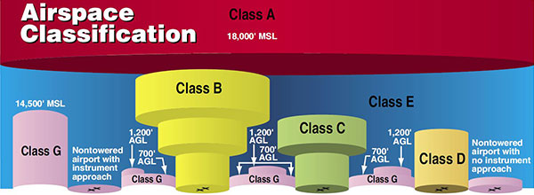
Class A: Class A airspace is generally the airspace from 18,000 feet mean sea level (MSL) up to and including flight level (FL) 600 (60,000 feet), including the airspace overlying the waters within 12 nautical miles (NM) of the coast of the 48 contiguous states and Alaska. For now, this airspace is of no concern to drone operators – you may not fly your drone in Class A airspace. It is not legal to fly in this airspace without an ATC clearance to do so. If you happen to be flying off of a mountain top that is 18,000 feet MSL or higher, the rules regarding height Above Ground Level (AGL) will apply – so you will still be able to fly. Class A airspace is not depicted on Sectional or Terminal Area charts.
Class B: Class B airspace is generally airspace from the surface to 10,000 feet MSL surrounding the nation’s busiest airports in terms of airport operations or passenger enplanements. This is the type of airspace that will most concern the FAA with regard to drone operations due to the high volume of airline traffic. The lateral dimensions of each Class B airspace area is individually tailored and differs between locations. It is important to note that the central area of Class B airspace surrounding an airport begins at the surface. An ATC Clearance is required for all aircraft to operate in the Class B airspace, therefore you may not fly your drone within Class B airspace. If you wish to fly your drone within 5 miles of any airport, the FAA requires you to call the control tower of that airport. Class B airspace is depicted on Sectional and Terminal Area charts by a solid blue line:
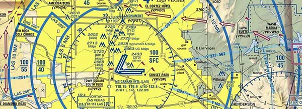
The Class B airspace for KLAS (McCarran International Airport) is contained within the solid blue lines. The altitudes covered by the airspace are depicted by a ceiling number over a base number in feet MSL. So 100/SFC means that the airspace in that area extends from the surface to 10,000 feet MSL. 100/40 means the airspace in that sector extends from 4,000 to 10,000 feet MSL, and so on.
Class C: Class C airspace is generally airspace from the surface to 4,000 feet above the airport elevation (charted in MSL) surrounding those airports that have an operational control tower, are serviced by a radar approach control, and have a certain number of IFR operations or passenger enplanements. Each Class C area is individually tailored, however, the airspace usually consists of a surface area with a five NM radius, an outer circle with a ten NM radius that extends from 1,200 feet to 4,000 feet above the airport elevation, and an outer area without dimensions which denotes the range of the radar coverage provided. You may not fly your drone within Class C airspace. If you wish to fly your drone within 5 miles of any airport, the FAA requires you to call the control tower of that airport. Class C airspace is depicted on Sectional and Terminal Area charts by a solid magenta line:
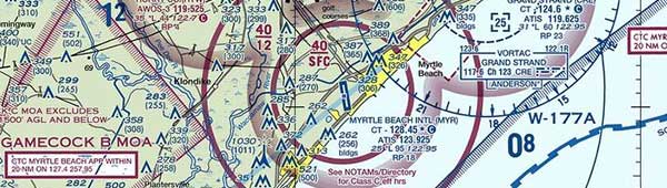
The Class C airspace for KMYR (Myrtle Beach International Airport) is contained within the solid magenta lines. The altitudes covered by the airspace are depicted in the same fashion as that for Class B airspace.
Class D: Class D airspace is generally airspace from the surface to 2,500 feet above the airport elevation (charted in MSL) surrounding those airports that have an operational control tower. The configuration of each Class D airspace area is individually tailored and when instrument procedures are published, the airspace is normally designed to contain the procedures. Arrival extensions for instrument approach procedures (IAPs) may be Class D or Class E airspace. You may not fly your drone within Class D airspace. If you wish to fly your drone within 5 miles of any airport, the FAA requires you to call the control tower of that airport. Class D airspace is depicted on Sectional and Terminal Area charts by a dashed blue line:
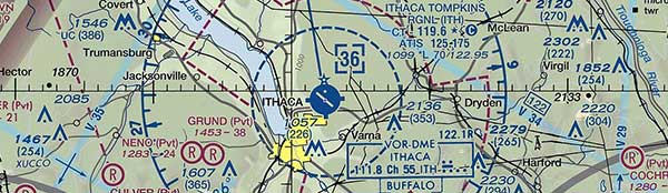
The Class D airspace for KITH (Ithaca Tompkins Regional Airport) is contained within the dashed blue lines. The altitudes covered by the airspace are depicted in the same square box containing a the 36 — this Class D airspace extends from the surface to 3,600 feet MSL.
Class E: If the airspace is not Class A, B, C, or D, and is controlled airspace, then it is Class E airspace. Class E airspace extends upward from either the surface or a designated altitude up to the overlying or adjacent controlled airspace. No matter where you are, Class E airspace is always somewhere above you! When designated as a surface area, the airspace is configured to contain all instrument procedures. Also in this class are federal airways, airspace beginning at either 700 or 1,200 feet above ground level (AGL) used to transition to and from the terminal or en route environment, and en route domestic and offshore airspace areas designated below 18,000 feet MSL. Unless designated at a lower altitude, Class E airspace begins at 14,500 MSL over the United States, including that airspace overlying the waters within 12 NM of the coast of the 48 contiguous states and Alaska, up to but not including 18,000 feet MSL, and the airspace above FL 600.
An aircraft does not need a specific ATC clearance to operate in Class E airspace, despite the fact that it is “controlled” airspace. Controlled airspace in the case of Class E serves the purpose of insuring that an aircraft will remain within airspace that has been pre-screened by the FAA to allow safe transition of that airspace with or without the help of Air Traffic Control. This is especially true when it comes to facilitating a safe transition from enroute altitudes to an airport environment under IFR conditions. WHOA, that’s confusing ! I will elaborate! To start, here are a few examples of Class E airspace depicted on aeronautical charts:
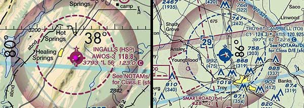
In the above image the magenta dotted line around Ingalls Airport on the left depicts Class E airspace starting at the surface and designated for that airport. The airport on the right shows standard Class D airspace with a magenta dotted area on the left. This area is to the lower left of the airport is a Class E extension to the Class D airspace. Its purpose is to provide protected airspace for aircraft flying instrument approaches into the airport. The airspace is considered protected because it has been pre-screened for obstacles.
Let’s highlight what’s important. To start – we won’t be flying our drone higher than 400 feet AGL anywhere, so we can eliminate the need to consider accidentally flying into Class E airspace which begins at 700 feet AGL or 1,200 feet AGL. The only thing left for us to be aware of is when Class E airspace is present at a Nontowered Airport with an Instrument Approach (such is the case with Watertown airport in the above image). In this case, Class E airspace begins at the airport surface and extends upward. The first step is to take a look at a current sectional map and to identify whether or not your planned flight is near a Nontowered Airport with an instrument approach. On a sectional map, airports with control towers are shown in blue and airports without control towers are shown in magenta. Magenta airports with a magenta dotted line around them indicate that within that area, Class E airspace starts at the surface.
A prime example of this is KHSP, Ingalls airport (see image above). The radius of this Class E airspace is approximately 5 nautical miles. There is no control tower for you as a drone pilot to call in this case, and so the big question is – can I fly my drone near this airport? Well, the moment you lift off the ground, you are technically flying in protected, controlled airspace. So the short and most conservative answer is NO, you cannot fly near this airport. What about the long answer then? Ok, I will give you my best subjective answer.
Would I fly near this airport? I would not fly a drone within 3 miles of the center of this airport under any circumstances. Low flying drones that close in could be both a danger and distraction to inbound or outbound aircraft. As you get closer to an airport, aircraft must transition through their cruise altitude and of course pass through our 400 feet AGL flying limit in order to land. Therefore, if you’re flying your drone too close to an airport between ground level and 400 feet AGL, you could easily end up in the flight path of an approaching aircraft. Between 3 and 5 miles from an airport I would fly my drone and always remain below 200 feet AGL. This would provide an additional buffer between the drone and aircraft flying into or out of the airport. Pilots make mistakes too, so you can’t always count on them to be at the right altitude at the right time. Leaving an extra buffer cannot hurt.
Why is 3 miles my magic number, you ask? Well, when aircraft fly an approach into an airport, they generally fly a 3 degree glide path until they land. Sometimes they fly steeper approach angles, sometimes shallower. On a standard 3 degree glide path, when the aircraft is 1 Nautical Mile from the beginning of the touchdown zone on the runway their altitude should be 318 feet AGL. At distance of 2 nautical miles from touchdown, the aircraft should be at an altitude of 636 feet. 2 nautical miles is equal to roughly 2.3 statute miles. So if you are 3 statute miles away from any part of the airport in this Class E airspace, I’d say that you’d probably be clear of any full scale aircraft making a normal approach into this airport.
I say probably for 2 reasons: 1) People screw up. Yes, even in full scale aircraft. Sometimes they fly lower than they should. It happens, especially near an airport. 2) Minimum Safe Altitudes, which I covered in point 1 above.
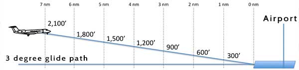
Aircraft altitude vs. distance while on a standard 3 degree glide path into an airport.
Remember that if the airport you’re considering flying near is in Class E airspace and out in the middle of nowhere (no towns, cities, or structures around), the pilot of an inbound or outbound aircraft might fly at an altitude lower than 400′ AGL. It would be completely legal to do so. Such might be the case in a place like Alaska, or at a small airport in the middle of the mountains or desert. If you have any doubts about whether or not you should be flying in the vicinity of an airport in Class E airspace, contact the local FAA Flight Standards District Office FSDO and ask to speak with an operations inspector – OR just don’t fly. The FAA needs to write some very clear cut laws regarding drone operations near smaller airports as their current guidance on Know Before You Fly is not regulatory, nor is it detailed enough.
Class G: Uncontrolled airspace or Class G airspace is the portion of the airspace that has not been designated as Class A, B, C, D, or E. It is therefore designated uncontrolled airspace. Class G airspace extends from the surface to the base of the overlying Class E airspace. Although ATC has no authority or responsibility to control air traffic, pilots should remember there are visual flight rules (VFR) minimums which apply to Class G airspace. This airspace presents no specific issues/problems for drone operators, UNLESS – there happens to be an airport nearby. A prime example of this is 913, West Liberty Airport (see below). In this case, I’d personally use the same guidance I outlined above for an airport located within Class E airspace. However, the FAA really needs to issue a regulation to cover the flight of drones in the vicinity of small airports.
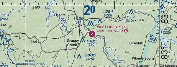
West Liberty Airport is an example of an airport with Class G airpspace above it. The Class E airspace over this airport begins at 14,500 feet MSL.
Special Use Airspace:
Special Use Airspace will exist in locations where certain types of aerial activity must be confined, or where limitations may be placed on transitioning aircraft that are not part of those activities. I will provide you with a quick outline of the different types of special use airspace. If you plan your drone flight in the vicinity of such airspace it is important for you to read up in detail about the particular restrictions associated with the airspace you are near. You would do so by accomplishing one or more of the following: reading the information on the appropriate National Aeronautical Charting Group (NACG) en route charts, sectional aeronautical charts, reading a current Airport Facilities Directory, checking Notices to Airmen (Notams), and possibly contacting the agency in charge of the special use airspace in your area.
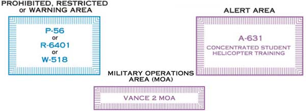
Examples of how special use airspace is depicted on Sectional and Terminal Area charts.
Prohibited Areas: Flight of any/all aircraft is prohibited in the defined dimensions of these areas. These areas are established for reasons of security or national welfare. Examples of this type of airspace include Camp David and the National Mall in Washington D.C. No drone flying within this airspace under any circumstances.
Restricted Areas: Areas where operations are hazardous to nonparticipating aircraft and where flight of aircraft, while not completely prohibited, is subject to restrictions. Restricted areas may contain unusual, often invisible, hazards to aircraft. For example: artillery firing, aerial gunnery, or guided missiles. In order to fly in this airspace you must either be routed through by an IFR (Instrument Flight Rules) clearance, or have authorization from the agency controlling the airspace. No drone flights within this airspace are permissible unless you speak to the controlling agency and get permission to fly in the airspace. Depending on the specific airspace, you may be able to fly a drone below the floor of the airspace.
Warning Areas: Similar to restricted areas, however, the U.S. government does not have sole jurisdiction over the airspace. Warning areas begin 12 nautical miles from the coast of the United States and extend outward, covering defined dimensions. It may cover domestic or international waters, or both. No drone flights within this airspace are permissible unless you speak to the controlling agency and get permission to fly in the airspace. Depending on the specific airspace, you may be able to fly a drone below the floor of the airspace.
Military Operations Areas (MOAs): Airspace with defined vertical and lateral limits established to separate military training activities from IFR traffic. MOAs are defined on the backs of sectional aeronautical charts with the times of operation, altitudes affected, and the controlling agency. Drones should not be operated in defined airspace for MOAs.
Alert Areas: This airspace contains a high volume of pilot training or unusual aerial activity. Drones can be flown under this airspace without issue as long as all other airspace regulations are adhered to (operating near airports, Class A, B, C, D, E, G).
Controlled Firing Areas (CFAs): CFAs contain activities, which, if not conducted in a controlled environment, could be hazardous to nonparticipating aircraft. Not charted and not really a concern for drone operators. Chances are, you’ll encounter armed people on the ground if you get near airspace affected by a controlled firing exercise.
Other Types of Airspace (yes, there’s even more)
I will not cover all of these, only the ones I think a drone operator should be familiar with.
Military Training Routes (MTRs): These are used by military aircraft to maintain proficiency in tactical flying. They are depicted on Sectional Charts and Low Altitude IFR charts. MTRs are usually below 10,000 feet MSL and flown at speeds in excess of 250 knots. Their identifiers on charts either start with an IR or a VR followed by a number – like this: VR1289. Those routes with no segments above 1,500 feet AGL are defined by 4 numbers (ie. VR3943). MTR’s with one or more segments above 1,500 feet AGL are identified by 3 numbers (ie. IR390, VR240). Do not fly your drone near MTR’s as military aircraft do not necessarily abide by FAA minimum safe altitudes and may operate well below 400 feet AGL and very high speeds. Colliding with an aircraft moving at over 250 KTS could prove disastrous for the pilot of that aircraft.
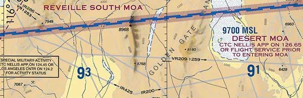
Military Training Routes (MTR’s) shown in grey.
Temporary Flight Restrictions (TFRs): These are issued as a flight data center (FDC) Notice to Airmen (NOTAM). You check them by entering the airport closest to where you are into the FAA NOTAM retrieval website. They will be located under the ARTCC Notices, TFRs and Special Notice section. A TFR NOTAM begins with the phrase “FLIGHT RESTRICTIONS”, followed by the location of the temporary restriction, effective time period, area defined in statute miles, and altitudes affected. The NOTAM also contains the FAA coordination facility, telephone number, the reason for the restriction, and other information. A drone operator should always check for these prior to going out flying. TFRs are issued for the following reasons: protect people/property in the air or on the ground, protect operations of disaster relief aircraft, prevent unsafe congestion of sightseeing aircraft above an incident or event, protect the President, Vice President, or other public figures, and for various other reasons.
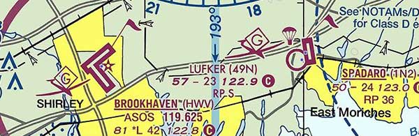
Parachute Jump Aircraft Operations: These are published in the Airport/Facility Directory (A/FD). Sites that are used frequently will also appear on sectional charts (commonly referred to as “sectionals”). Drone pilots will want to stay well clear of these areas to avoid a midair collision with a parachuting human. Where there are frequent operations involving parachute jumping or glider operations, there will be a little parachute or glider posted right next to the airport as well. See those here:
National Security Areas (NSAs): These are comprised of airspace with defined vertical and lateral dimensions established at locations where there is a requirement for increased security and safety of ground facilities. Prohibitions are disseminated via NOTAM and drone operators should remain clear of this airspace.
5. Visit your Local FBO and Take a Flying Lesson
Why it’s important: For around $200 you can go to your local airport’s Fixed Base Operator (FBO in aviation speak) and set up an introductory flight lesson. I recommend this for every drone pilot because it will help you understand what the pilot of a real aircraft sees and what tasks must be accomplished to pilot an aircraft. As drone technology progresses, there will eventually be a complete merge with full scale aviation – so the sooner you learn about real flying, the more ahead of the game you will be. From a safety aspect, knowing a about what goes inside an aircraft will make you a more competent drone pilot from the ground.
6. Familiarize Yourself Flight Operations Unique to your Local Area
Why it’s important: Depending on where you fly your drone you may encounter localized flight operations that present unique hazards to be aware of. Such operations include things like small heliports at hospitals, police aviation units, private air strips, small military units such as Air/Army National Guard, and areas needing specific operating rules created by the FAA for unusually dense air traffic.
I’ll give you a quick example of one of the most busy traffic areas in the United States, located right in my home town – NYC. In the vicinity of Manhattan we have the convergence of Class B airspace from 3 major airports: JFK, LaGuardia, and Newark International. These airports handle an enormous volume of airline traffic and many of you have probably flown into one of them and noticed the scale of operations here. In addition to these there major airports we have a few smaller ones which handle a lot of corporate jet traffic. Airports like Teterboro and Westchester County insure that our air traffic controllers are among the sharpest and busiest on the planet.
You’d think that would be a sufficient amount of traffic to pack into such a small area, however we also have many small airports nearby and a lot of private airplane and helicopter traffic. Some of that traffic transitions through the airspace and some of it is very localized. Of specific concern to drone operators is the air traffic directly around Manhattan. Everyone wants to fly their drones to get a view of the Manhattan skyline. Without giving it a second thought, one would gather that flying over the Hudson or East Rivers would be a grand idea. Turns out it is definitely not a safe or permissible thing to do. However in order to know this, you’d have to do a little research to find out why.
The airspace over the Hudson and East Rivers is filled with VFR airplane and helicopter traffic. This includes tourism helicopters, the NYPD, local pilots, and businessmen commuting to and from Manhattan. There are several heliports on Manhattan and there is even a float plane service that lands Cessna Caravans on the East River. For this reason, the FAA has reserved the airspace from the Surface up to but not including 1,300 feet for VFR aircraft operations. They have in fact outlined this special airspace on Sectional and Terminal Area Charts as well as in a PDF document. Since this airspace has been outlined for special use by full scale aircraft, flying a drone in any of that airspace (even below 400 feet AGL) could put a drone operator in direct conflict with a full scale aircraft. Knowing this information is your responsibility the moment you elect to fly a drone.
This example is an extreme one, as there are very few areas as congested and complex as this one. In Manhattan operations are so specific that even local heliports such as this one on 30th Street, have their own particular departure and arrival procedures. For a drone operator to fly safely, he or she must familiarize themselves with the conditions in their area. The details of local operations are important for insuring safe flights for everyone. If you have trouble finding information about your local area, the best thing I can recommend is to sit down for a few minutes with a flight instructor and ask them to help you become familiar with the unique hazards you may face when out flying your drone.
Resources:
- FAA Course on Airspace Classes: download PDF
- UAV Coach – UAV Boot Camp Course – This is a great course for someone who wants to sit down and have a lot of information infused into them. However, unlike all the awesome info I’ve provided here, it is not free ($89). However, I wouldn’t include it here if it wasn’t a solid resource.
- VFRMAP – Here you’ll find online aeronautical maps, a searchable Airport Facility Directory, as well as a few other useful resources.
- SkyVector – Another online resource with aeronautical maps and an airport directory.
- FAA Aeronautical Chart User’s Guide – Online information from the FAA to help you decipher all those esoteric scriptures and symbols you see on Sectional and Terminal Area charts.
- FAA Airport Facility Directory – Although an AFD is included in 2 of the links above, this is where the official info is! If you need to look up the phone number for a control tower or other facts about an airport, you will find it here.
- FAA Charts (raster graphics) – Who says the Federal Government doesn’t give away anything for free? Here you can find extremely high resolution TIFF images of all the available aeronautical charts. A very cool resource.
- FAA NOTAM lookup website – As the title suggests, this is the place to search for Notices to Airmen.
- FAA Special Use Airspace – This is the place to look up active times and altitudes covered by Special Use Airspace.


